The Christmas BlizzardBuffalo, NY - December 23-26, 2022
Anatomy of a Weather Catastrophe
Anatomy of a Weather Catastrophe
by Tom Niziol
Introduction
During the Christmas holiday weekend of 2022, Buffalo, NY was buried by a catastrophic lake-effect snow blizzard. Over the course of nearly 4 days, forty-seven people lost their lives as a direct result of the winter storm. This begs an answer to the question “How could the most winter savvy-city in the world, in the year 2022, backed by sophisticated numerical weather models and exceptional communication networks suffer such a tremendous loss of life?”
It all is part of the process that I describe as a “Weather
Catastrophe”, where several meteorological as well as logistical and societal factors, each
of which produces its own impacts on the public, come together at the wrong
place and the wrong time. The result follows the old saying that “The Whole is
Sometimes MUCH Greater Than the Sum of the Parts”. In this presentation I plan to piece together
those parts to highlight how catastrophes like this one happen and hopefully,
how we all can be better prepared when it happens again, because history does
repeat itself.
 |
Fig 2: Storm total snowfall, December 23-27, 2022. Note 3 narrow strips of heaviest snowfall downwind of Lake Erie, one to the north of Buffalo, one south, and one directly over the city. The greatest snowfall was recorded in North Tonawanda at 59.7", just north of downtown Buffalo, followed closely behind by the Buffalo airport, about 7 miles east of downtown, with 51.9" |
Buffalo's Location and Lake-effect Snow
Buffalo has a well-deserved reputation for snow. With an
annual snowfall just this short of 100”, it regularly deals with impactful
lake-effect snowstorms. Most of them result in lots of travel woes but
fatalities directly attributed to these storms are usually quite low.
 |
Fig 3: The average annual snowfall, recorded at the Buffalo airport, based on monthly climate normals from 1991-2020. |
Citizens of Buffalo, NY often have to hear comments like “Buffalo, isn’t that where it snows every day in winter?” or “how do you handle that much snow?”, when they travel anywhere in the world. In fact, Buffalonians wear that badge of honor, noting how they are used to it and except for having to drive in the snow and shovel it, they actually don’t mind it that much.
The snowy reputation has everything to do with the location of Buffalo on the eastern tip of 225-mile Lake Erie, one of 5 Great Lakes that are often described more like “inland fresh water seas” because of their massive size. In fact, the Great Lakes overall have a surface area that exceeds that in 39 of the 50 states. The Great Lakes are so large they make weather all their own and the most infamous type of weather are mesoscale (or small scale) lake-effect snowstorms.
 |
Fig 5: When cold air from Canada crosses the warmer water of the Great Lakes, heat and moisture rise from the lake. As the air parcels rise into the colder air, moisture is turned into snow crystals that collect into millions of snowflakes in those clouds. The wind aligns and directs those clouds downwind of the lakes across places like Buffalo, NY. |
The wind direction determines where all of that snow will eventually be deposited downwind of the Great Lakes and the type of snowbands that occur. Multiple banded snows occur when winds are directed across the shorter axis of lakes like Lake Erie or wide expanses of irregularly-shaped bodies of water like Lake Superior. Although they may cover a greater area with snowfall, they are generally much weaker than their counterparts. They are formed under horizontal or parallel roll convergence and produce many wind-parallel bands of weak convection.
When winds are aligned down the long axis of elliptically-shaped lakes like Lake Erie, single "mega-bands" of snow develop. That's because winds from those two parallel shores undergo frictional and heat differences that result in convergence over the narrow body of water to produce that one "mega-band" of snow. The prevailing winds within the cloud layer extend the convective snow clouds along that strong convergence zone far inland. The band might only be 10 to 15 miles wide while stretching over 100 miles at time. These are the bands that produce snowfall rates of up to 6" per hour, and often thundersnow as well. Lake Erie is designed to take full advantage of the prevailing WSW winds during late Fall and Winter to produce these mega-bands which often set up right over Buffalo and its suburbs.
 |
Fig 6: Multiple snowbands develop over the shorter fetch of elliptically-shaped lakes or over irregularly shaped bodies of water. Single bands develop along the long axis of elliptically shaped lakes such as Lakes Erie and Ontario |
 |
Fig 7: Two types of lake-effect snow bands. Multiple banded snows, often referred to as horizontal roll convection, develop when winds are directed across wide or irregularly-shaped lakes like Lake Superior (left) or the shorter fetch of elliptically-shaped lakes like Lake Erie. When winds blow down the long axis of narrow, elliptically-shaped lakes like Lake Erie (right), frictional and heat differences between the land and lake cause winds to converge over the middle of that long, narrow body of water. This results in a single, narrow convergence zone over the center of the lake, producing a mega-band of snow falling at rates up to 6" per hour. |
The image below shows a view of the snowcover a couple days after the November 17-19, 2022 lake-effect snowstorm. It highlights just how small the scale of these storms can be! Below that is a series of radar images showing a 12-hour period during that storm. You can see how that extremely narrow band of heavy snow moved from Buffalo northward to Niagara Falls. At one point the width of the snowband was as little as 12 miles. For residents trying to go about their daily lives, this presents a big challenge.
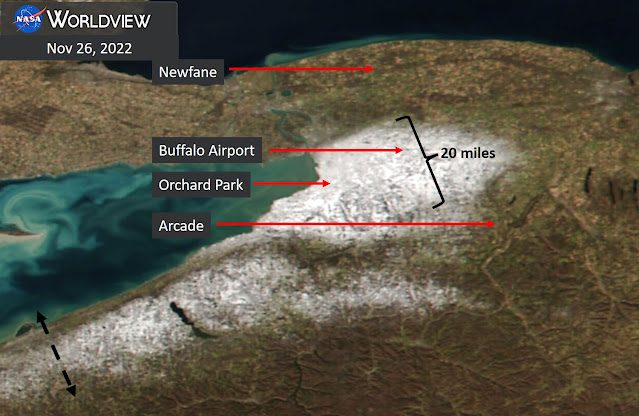 |
Fig 8: The November 2022 lake-effect snow event dropped as much as 81" of snow in parts of Western New York. This visible satellite image from a few days after the storm highlights just how narrow the swath of snow can be. Travelling from the Southtowns to Northtowns in Western New York would take you from green grass through deep snow and back to green grass again.
|
 |
Fig 9: This radar animation from November, 18-19, 2022 is an example of how subtle shifts in the wind direction can move snowbands from one area to the next. In the above radar animation, a gradual wind shift from W (265°) to SW (250°) and eventually SSW (230°) moved the snowband from suburbs south of Buffalo, through the city and eventually to suburbs north of Buffalo over the course of just 12 hours.
|
 |
Fig 10: View from downtown Buffalo looking toward the south of the north wall of a lake-effect snowstorm in November 2014. Driving into this band is surreal, going from clear skies into a rgaing whiteout within a few hundred yards of entering the storm. (Photo credit Shawn Smith via NOAA / NOAA) |
Historical Storm - Blizzard of '77
Buffalo’s snowy reputation was cemented into history during the month of January 1977. That winter of 76-77 was brutal for much of the US. In fact, January ’77 is the second-coldest month in recorded US history, and for the Eastern US it was the coldest January on record. In Buffalo, NY, it had been so cold leading up to the month that Lake Erie had frozen over by mid-December. In fact, an astonishing snow depth of 51” was reported in Buffalo on the morning of January 27.
That day started out very
serene for January, with a balmy mid-winter temperature of 25 degrees at
mid-morning. However, at 11:30AM an exceptionally strong Arctic front swept
across the region and Buffalo was in the throws of a 5-day blizzard like they
had never seen. Before it was all over, 29 people lost their lives in this
storm, many buried by snow, frozen in the cars. Officials vowed this would
never happen again. But Nature has a mind of its own and history DOES repeat
itself.
 |
Fig 11: Photos from the Blizzard of 77'. News reporters (left) are walking across the tops of cars buried in the snow next to the runway at the Buffalo airport. Red Cross workers (right) using snowmobiles to get around check cars by pounding on roofs for survivors. (photo credit Buffalo News: Robert Smith) |
Pre-Cursor to The Big Event - November 17-19, 2022
Fast-forward to late Fall and early Winter of 2022 which was topsy-turvy weatherwise for Buffalo residents. An early season lake-effect snowstorm during November 17-19 (shown in previous images), dropped unbelievable amounts of snow from the city to the heavily populated suburbs south of the city (known as The Southtowns). The Buffalo airport recorded 36.6” of snow from this multi-day storm, and that paled in comparison to the snow that piled up in the Southtowns where Hamburg, NY, received 81” and Orchard Park, home of the NFL Buffalo Bills accumulated 80”. The snowfall map below shows the incredible gradient of snowfall as one travelled from south to north through the city of Buffalo.
Travel impacts from the event were significant, but there were fortunately only 2 deaths in the Buffalo area attributed to the storm, both from heart attacks shoveling snow. Yes, there was tremendous snowfall from this storm. However, sustained winds were not that strong during the event, generally below 20 mph. Temperatures were also quite mild, only dropping to 23 degrees. Also, the lake-effect storm fired up during the overnight hours, south of Buffalo, and when it did move north through the city on the 3rd day of the event, that was also during the overnight hours when there was very little traffic on roads. Simply put, very few people were outiside in the elements.
Surprisingly, the rest of the month was so warm, that by the 30th, every bit of up to 80" of snow had melted. Even more bizarre, through the first 22 days of December, the high temperature each day exceeded 30 degrees.
 |
Fig 12: Storm total snowfall for the November 16-21, 2022 lake-effect snow event. As much as 81" of snow was measured in the town of Hamburg, just south of the city of Buffalo. |
The Big Event - December 23-26, 2022
Five weeks later, in the days leading up to the busy 2022 Christmas Holiday, NWS Buffalo forecasters were looking at very foreboding signs of what was being advertised by the sophisticated computer models as a multi-day, high impact lake-effect snowstorm. In fact, by comparing the model data with past lake-effect snowstorms, a method known as analogs, it was apparent this upcoming storm was no garden variety lake-effect snowstorm that winter savvy citizens of Buffalo are all too familiar with. No, this storm was going to be much worse. But worse than the 80” lake-effect storm that pummeled the area back in November? Possibly, due to many other factors, and forecasters realized it could be so impactful that they even stated on one of their daily forecast discussions that this could be a ”once in a generation” storm.
The large-scale weather pattern setting up to produce this epic storm was textbook. Several thousand feet in the atmosphere, the winter jet stream was buckling to bring exceptionally cold air down from the north pole, right across the Great Lakes. An Upper Level Low at 500mb was predicted to close off right over James Bay Canada, the perfect spot to set up conditions in the lower atmosphere to produce an intense, single band snowstorm off Lake Erie. When the jet stream closes off these Lows, they slow down their eastward movement, assuring an extended period of winds that blow out of one particular direction. It also provides a deep column of cold air to allow storms to grow several thousands of feet into the atmosphere. In the world of lake-effect snow, as long as conditions of deep, cold air and the same wind direction remain in place, these narrow intense bands of snow will remain stationary over one particular location, pummeling the area with blizzard conditions at times.
 |
Fig 13: 500mb analyses from December 21-26, 2023. You can see how the 500mb Low closes off and sets up over James Bay Canada, a perfect location to produce lake-effect snow over Buffalo. Note, the reports from Buffalo, NY were not available from December 24 through 26 because it was not possible to launch a weather balloon in those blizzard conditions. |
 |
Fig 14: The Low responsible for the lake-effect blizzard dropped an astounding 35mb in 24 hours from 1005mb on December 23 at 00z to 970mb on December 24 at 00z, undergoing the rapid deepening known as "bombogenesis". |
 |
Fig 15: 60-hr NAM model initialized at 18z (1PM EST) on Fri December 23, 2022. Note, the blizzard had already been going for 6 hours when this model started. This is a great example of the "steady-state" nature of these types of lake-effect storms. Once the band sets up, as long as the wind direction does not change, one area could be under the "firehose" of snow for hours to days. |
The morning was eerily similar to a morning almost 45 years previous to that back in January 1977. The temperature at 6AM was 37 degrees under a little light rain and wind easterly winds at 5 mph. As people got ready for work, they might have wondered about the accuracy of the impending winter warnings for a big storm.
As most traffic headed into work at 7AM conditions
were still tranquil with a temperature of 34 degrees and light rain and fog
dropping visibility to 1.5 miles and 9 mph winds. Just as everyone was getting
into work, at 7:43 AM, the cold front slammed into Buffalo as winds howled,
gusting to 40 mph. By 8:00 AM the rain changed over to light snow. Out over the
lake, the Buffalo weather radar was showing the lake-effect snowband rapidly
developing and setting its sights on Buffalo. At 8:06 AM the visibility dropped
to 1/2 mile in moderate snow and winds were now gusting to 60 mph. By 8:39 AM
visibility was down to 1/4 mile in heavy snow and 8 minutes later a full
whiteout was occurring with visibility down to 1/8 mile. Whiteout conditions
meant nobody was going to be going anywhere soon. What transpired over the next 72 hours will
be ever etched into the minds and souls of Buffalo residents as a fierce
blizzard brought the city and its immediate suburbs to a standstill.
 |
Fig 16: The table shows the weather observations from the Buffalo airport. Look at how rapidly conditions deteriorated when the storm hit during and just after the height of the Friday morning rush hour. |
Fig 17: This video was taken on that Friday around 11AM by Reed Timmer near the waterfront in downtown Buffalo. You can hear and feel the raw power of the storm as it ramps up. Visibility was already dropping to zero at times in whiteouts. If you are caught outside in this type of weather, it is almost impossible to get to safety because you cannot see where you are going.
By 11 AM on December 23, under whiteout conditions, the
temperature had dropped to 21 degrees with winds gusting to 67 mph and a wind
chill of just one degree above zero. If you were not at home, you had a choice,
either try to brave the elements to go out and get home or hunker down and
wait. Traffic became stuck in its place
in many locations. As the afternoon wore on, conditions got even worse as the
temperature continued to plummet. By 5PM it was 7 degrees and with winds
gusting to 60 mph the wind chill had dropped to a dangerous -20 degrees. By
midnight, some 14 hours after the storm hit, the Buffalo airport had received
22.6” of snow, with other locations close by getting even more. The tremendous
winds piled snow drifts to height of 6 ft. or more, burying vehicles stuck in
their place with potential victims inside.
 |
Fig 18: The hourly weather observations from the Buffalo airport show that from 9AM through the rest of the day and night, the area was under whiteout conditions in heavy snow and winds gusting over 60 mph at times. |
Fig 19: Reed Timmer is standing on top of snow drifts that were as high as 10 ft. in this video clip. You can see cars almost completely buried under these drifts. Travel is impossible in these conditions.
It’s hard to fathom the fact that the area in and around the
city of Buffalo would remain in a whiteout through the entire night and ALL of
Christmas Eve. Daybreak on December 24th brought a temperature of 3
degrees and a wind chill of -22 with zero visibility still being recorded out
at the Buffalo airport. The rest of that
entire day and evening the winds gusted in the 40-50 mph range with wind chills
in the minus teens. Visibility remained near or at zero in the whiteout conditions
that piled snow drifts even higher. Emergency vehicles could not even get out
to conduct operations because it was just too dangerous. Another 17.9” was
officially recorded at the airport by midnight bringing the storm total to
40.5” of heavily drifted, wind-blown snow as the region headed into Christmas
Day.
 |
Fig 20: Christmas Eve was also one for the record books. It is almost unfathomable to think that the entire 24-hour period featured whiteout conditions in a raging blizzard, and that was an extension of the 21 hours of blizzard conditions from December 2. Winds gusted well over 40 mph for almost that entire time and winds chills bottomed out at -22°. |
As dawn broke on Christmas Day the city and surrounding suburbs looked like an Arctic wasteland. The narrow, intense band of lake-effect snow had moved south overnight, now impacting the Southtowns. Over the city and surrounding suburbs, the visibility gradually rose to 1 to 3 miles in blowing snow. The winds continued to howl with gusts over 30mph and the wind chills in the single digits. Nobody was going anywhere however, with drifts several feet tall covering almost all thoroughfares. The Buffalo International Airport, renowned worldwide for its plow operators’ snow-fighting skills, remained closed, not opening until 3 days later. There was light however at the end of the tunnel, as the parent large scale, Upper-Level Low that was parked over James Bay Canada was showing signs of weakening and beginning to move eastward.
 | |
|
But Mother Nature had one more punch to throw at Buffalo that night. In the wee hours of Monday morning, the winds briefly shifted from westerly to southwest again and the snowband that was well south of Buffalo began to migrate northward, sweeping through the city before dawn on Monday December 26. Even though it dumped another 7+ inches of snow across the region, after all that had happened, it didn’t seem like much, and fortunately it was still dark when it came through the region, sparing those who were sleeping one more nightmare of whiteout conditions.
 |
Fig 22: Hourly radar animation through the history of the blizzard with the wind speed, direction and wind chill at approximately the time of the radar image. The 3 main metro areas of Buffalo are highlighted here to show how very slight changes in the wind direction positioned the band over an entirely different part of town, You can also see how many times the band oscillated across the region. |
By late Monday those tallying up snowfall totals showed over
4 feet of snow (50.6”) had been measured at the Buffalo Airport. Three days of
exceptionally strong winds had piled drifts over 10 ft. tall in some areas. It
would still be a few days before life began to get back to normal. Clearing
snow from streets involved first checking buried vehicles for possible victims
inside, then moving those vehicles before front end loaders could come in and
break through snowdrifts that would allow plows to clear the roads. Residents
had the difficult task of removing snow from their driveways. Once again,
because of the snow drifts, many had to bring in plow operators with heavier
equipment to remove the snow.
In the wake of the catastrophe, harrowing stories emerged of survivors and those who became victims of this wicked storm. My own friend was one of those survivors. I had told he and his wife on the morning of the start of the blizzard to make sure he was hunkered down and set to stay put for at least a couple days. His wife left work early as the storm hit. She brought her friend home with her and the three of them decided to venture out and take her friend home before it got “too rough”. They drove south from the north side of the city right into the teeth of that snowband. After dropping their friend off they turned back to head home. A few miles later, in the heart of the whiteout, they drove their vehicle off the road and into a snowbank. They were now stuck, reality set in. They could not see a thing outside. They had an idea of where they were and checked on their GPS but nobody, AAA, even EMS personnel could go out in the storm by now. They knew a close friend who was a realtor and miraculously, had a house she was showing within a couple blocks of where they were stuck. They called her and she gave them the key code to get into the vacant house. In a harrowing walk through the whiteout, they managed to get to the house, which still had its heat turned on, and survived the night and the next day. Without that Guardian Angel, they may not have survived. So many people caught outside, either walking or in their cars, were not that lucky.
Lessons Learned
When the final numbers were tallied, 47 people lost their lives in this storm. According to a post made by Erie County (where Buffalo is located) Executive Mark Poloncarz, the fatalities were listed under the following causes:
 |
Fig 23: Social media post from Erie County Executive, Mark Poloncarz, listing the fatalities. One other fatality was attributed to the storm in Niagara county, just north of Erie county. |
There was a lot of finger-pointing as the storm unfolded and after the catastrophe began to wind down. City and county officials were criticized for not acting sooner to impose driving bans. They posted a driving ban 9AM that Friday morning, but it was after the storm began. The visibility had dropped to 1/8 mile by that time and winds were already clocked at 68mph. According to the Washington Post "New York's second-largest city has gone for years without an official emergency manager, whose job it is to create "procedures for responding to natural disasters and other emergencies" and lead and help coordinate the response."
The National Weather Service had been talking for days before the storm hit of the potential impacts from this storm. They even used the term “once in a generation”. But what does that term really mean to the public? I refer back again to the lake-effect storm that occurred just one month previous to this one, which dropped over 3 feet of snow in Buffalo and as much as 80” in the Southtowns and only resulted in 2 fatalities. How could this one be any worse?
This is where awareness, from the forecasters, Emergency
Management officials, politicians and the public must be raised to the next
level to communicate the combination of factors that would turn this storm into
a catastrophe. It is my definition of a
Weather Catastrophe, where several factors come together at the wrong place and
time and that combination of factors has much greater impact than any taken
individually. The whole becomes much greater than the sum of the parts. I have
seen this so many times in my career that it begs for better tools to “flag”
when a weather event crosses that line and becomes a catastrophe.
Let’s look at each factor and how they combined to produce
the catastrophe. I split them into meteorological, logistical and societal
factors in the table below. These are my own opinions and they may not be the
only answers to what led to the catastrophe but I feel they address the most
important aspects of the event.
 |
Fig 24: Table that shows the author's opinion of the factors that went into creating a weather catastrophe for the lake-effect blizzard of December 23-26, 2023. |
From the meteorological standpoint, the flowchart below helps to explain the concept of several impactful weather factors combining to produce much greater overall impacts on the public. The chart identifies the weather factors in gray.
 |
Fig 25: Flowchart that shows how the impacts of the combination of meteorological factors can be multiplied many more times compared to each individual factor. The whole is MUCH greater than the sum of the parts. |
Heavy snow typically causes traffic problems. Strong winds can take down tree limbs and cause power outages. Arctic temperatures in northern latitudes don’t necessarily freeze pipes etc. but they can prove impactful to vehicles not prepared for winter conditions and certainly can be dangerous to anyone spending a lot of time outside without adequate winter gear.
The impacts notch up VERY quickly though when you begin to combine these factors. In the chart above, the combination of heavy snow and strong winds produces whiteouts, making travel VERY dangerous. Snow begins to drift rapidly to block roads. Vehicles get stranded in those drifts, blocking other traffic. Strong winds and Arctic temperatures combine to produce dangerous wind chills. It greatly decreases the time one can spend outside without getting frostbite and hypothermia. When those 3 original factors are combined, the impacts increase at an even greater rate. To try to travel in any way when the region is experiencing heavy snow, strong winds and arctic temperatures is impossible. You almost certainly will get stranded in a vehicle and when you do, you now are looking the at very real possibility of freezing if you cannot get to safety. The only hope is that the storm abates soon enough to allow you to get to safety.
This is where the storm duration comes into play. It raises the impacts exponentially by making it necessary to survive life-threatening conditions for an extended period of time. In this case, storm duration was the “straw that broke the camel's back”. For those who were stranded outside, freezing to death was almost certain. In addition, for those who were inside and lost power, heating their homes became impossible in many cases. This combination of factors is how a weather catastrophe occurs.
The time of day and day of week the storm struck were very important logistical factors in my assesment. Because the weather was calm as most people were waking up and heading into work, there may have been a false sense of security to "go out and get things done before the storm hit". Finally, as with some of the most deadly historical blizzards that have occurred in the U.S., one other factor was extemely important. This storm hit so quickly and conditions deteriorated so rapidly, that nobody had time to respond and get back home or to safety. Remember, the weather essentially went from calm conditions to a raging blizzard in 1 hour, then continued as a full-blown whiteout blizzard for the better part of nearly 3 days. Total up all of these factors and you can easily see how they eventually tip the scales to create a Weather Catastrophe.
 |
Fig 26: The scale shows how each factor plays a role in impacts, and as they pile on, the impacts become greater and greater until that final factors, the duration of the event, tips the scale into a weather catastrophe. |
For the December 2022 blizzard, was there enough information available for the forecasters and emergency management to convey the potential for a catastrophic winter storm? Possibly. They did know when the storm would hit, that the storm would produce exceptional snowfall, would last for more than a day, would be accompanied by a long period of strong winds, and occur with rapidly falling temperatures which would lead to an extended period of life-threatening wind chills. However, the format in which they communicated the information was a standard template. All of that information is there, but much of it appears in most Winter Warnings that are issued.
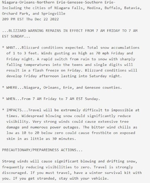 |
Fig 27: Winter Storm Warning issued by the National Weather Service office in Buffalo, NY on the afternoon before the blizzard struck. |
With the obvious point of playing Monday morning quarterback, would a statement such as the one below conveyed a better idea of the severity of this storm?
WHAT…A MAJOR BLIZZARD for at least a 2-day period with up to 3 feet of snow. Winds gust to 70 mph Friday and Friday night and over 40 mph through all of Saturday creating whiteout conditions. TRAVEL WILL BE IMPOSSIBLE. Temperatures will become very cold. Along with strong winds this will create life-threatening wind chills to -20° through the 2-day length of the storm. IF YOU ARE STRANDED OUTSIDE, YOU COULD DIE.
WHERE…Niagara, Orleans Genesee and Wyoming counties including Niagara Falls, Medina, Batavia, Buffalo, Orchard Park and Springville
WHEN…The blizzard will strike between 8AM-9AM Friday. Conditions will get bad very quickly. Whiteouts will then occur for the better part of the next 2 days, through all of Saturday MAKING TRAVEL IMPOSSIBLE.
IMPACTS…MAJOR BLIZZARD. TRAVEL WILL BECOME IMPOSSIBLE. Cars and people will become stranded due to whiteouts and roads drifted over with snow. There will also be life-threatening wind chills for the course of the storm. Because this blizzard could last over 2 full days, it will mean if you are stranded outside, YOU COULD DIE. Emergency personnel may not be able to rescue you. This will not be a typical lake-effect snow storm. IT WILL BE MUCH WORSE.
There will likely be several papers and studies on the impacts of this storm, especially the number of fatalities that occurred. Hopefully this will lead to better communication of the expected impacts that would put a storm like this one well above and beyond the "typical" winter storm.
Until then, I remember something an old WWII forecast told me when I was training as an intern at the NWS Buffalo office long ago. He said “that any forecast can be the most accurate prognostication, written by the most intelligent PhD, but if you cannot communicate its impacts effectively to the public, it is not worth the piece of paper it’s written on”. There needs to be a better system to highlight what separates a garden variety storm (a.k.a. November 2022 event that produced 3 to 6 ft. of snow) from the truly catastrophic storm such as the Christmas Blizzard of 2022 in Buffalo, NY.


